Summer makes another comeback across Kansas

WICHITA, Kan. (KWCH) - We are waking up to a few storms, mainly along and east of I-135. All areas will be dry by late morning, if not sooner, and nothing heavy or severe is expected. Sunshine takes over this afternoon sending temperatures into the upper 70s and lower 80s.
Summer takes over tomorrow and will be with us through the weekend. Highs in the lower 80s on Friday will be followed by middle to upper 80s on Saturday and Sunday. The warmer temperatures will be accompanied by strong winds from the south occasionally gusting to over 40 mph, especially on Sunday.
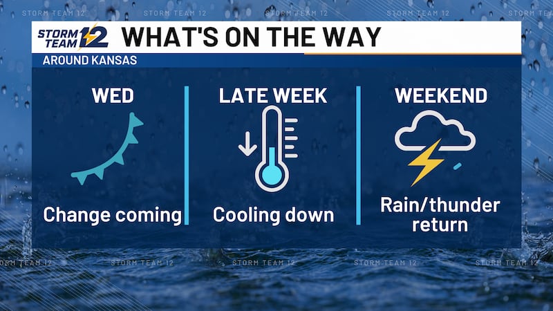
Our next cold front will sweep across the state on Sunday night. Any showers or storms associated with the front will be confined to central and eastern Kansas, and temperatures will only fall a few degrees, into the 70s on Monday and Tuesday.
Looking ahead… here we go again. Another taste of summer arrives on Wednesday as temperatures rebound into the 80s and the warm spell should last through late next week.
WICHITA AREA FORECAST:
Today: Isolated storms early; clearing and warmer. Wind: S 10-15. High: 80
Tonight: Mostly clear to partly cloudy Wind: SE/S 5-15. Low: 62
Tomorrow: Becoming mostly sunny and warm. Wind: S/SW 10-15. High: 83
Sat: Low: 61. High: 86. Mostly sunny, breezy, and warm.
Sun: Low: 65. High: 87. Partly cloudy and windy; overnight storm chances.
Mon: Low: 63. High: 75. Few showers early; mostly cloudy and cooler.
Tue: Low: 60. High: 78. More clouds than sun.
Wed: Low: 64. High: 83. Mostly sunny, breezy, and warmer.
Copyright 2025 KWCH. All rights reserved. To report a correction or typo, please email news@kwch.com